Gaby
Lord of Altera
Gaby wants to make awesome high-definition maps for everyone.
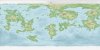
I was reading through the Cartographer's Guild forums, and I've been inspired to draw maps. been wanting to do this for a while but now I'm pumped and ready.
that isn't indicative of the final project (and it's actually a trace of the borders and landmarks lol), but essentially,
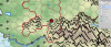
I'll be making high-def versions of nation's maps, following the precise coastline and drawing more naturalistic borders for stuff. also part of my services is finding points of interest inside your nation and analyzing the geography and borders. example:
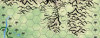
the Lonely Mountain is north of New Kindar @Exosferik
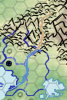
the mountains where Centurius resides is split in two by a canyon that ends in the north of Imdolia, becoming a river that splits the latter country in half.
(("ok Gaby, how'd you know thats a canyon?" mountain range interrupted by sudden hills. a river happens to be flowing from the end of that line of hills. canyons are caused by rivers. it was a deduction. B) the sort of deduction that I would do for a fee.))
so I guess cause these things need applications,
Name of Nation:
Scope of Map: (just the nation? the nation and neighboring nations? the whole continent? don't ask me to map out the entire world pls.)
Any Interesting Stats?
Any Interesting Lore? (natural wonders you'd written about already)
Any Points of Interest to Locate? (manmade things you'd written about in lore)
Capital Placement: (note: this is WITHIN it's current hex. I'm not moving it outside the hex Sinclair placed it in)
- you want me to figure it out for myself, do you want to just keep it at the center of the hex, or do you want to tell me where you want it?
- if you're letting me pick, I need to know why your was your capital city chosen because it was one of the biggest cities in the nation? because it was a defensible place? because it was at the stop of a profitable trade route? because it rests near a sacred location? or for some other reason?
What kind of map would you want? (you know, there's like, simple but charming hand-drawn maps, those fanciful hand-drawn maps from like Tolkien and stuff, those antique map styles with the lines everywhere (and I have no idea how to do), then all those modern map styles. I mean, I might feel most comfortable with my hand-drawn style, but you're allowed to ask for other styles. once I get some maps drawn, I'll show them as example styles.
and idk ok add anything you want me to know.
for final product maps, I'd most likely be doing them in hand-drawn style, with full color and all that jazz. they will also have a legend, and be very very pretty.
I was reading through the Cartographer's Guild forums, and I've been inspired to draw maps. been wanting to do this for a while but now I'm pumped and ready.
that isn't indicative of the final project (and it's actually a trace of the borders and landmarks lol), but essentially,
I'll be making high-def versions of nation's maps, following the precise coastline and drawing more naturalistic borders for stuff. also part of my services is finding points of interest inside your nation and analyzing the geography and borders. example:
the Lonely Mountain is north of New Kindar @Exosferik
the mountains where Centurius resides is split in two by a canyon that ends in the north of Imdolia, becoming a river that splits the latter country in half.
(("ok Gaby, how'd you know thats a canyon?" mountain range interrupted by sudden hills. a river happens to be flowing from the end of that line of hills. canyons are caused by rivers. it was a deduction. B) the sort of deduction that I would do for a fee.))
so I guess cause these things need applications,
Name of Nation:
Scope of Map: (just the nation? the nation and neighboring nations? the whole continent? don't ask me to map out the entire world pls.)
Any Interesting Stats?
Any Interesting Lore? (natural wonders you'd written about already)
Any Points of Interest to Locate? (manmade things you'd written about in lore)
Capital Placement: (note: this is WITHIN it's current hex. I'm not moving it outside the hex Sinclair placed it in)
- you want me to figure it out for myself, do you want to just keep it at the center of the hex, or do you want to tell me where you want it?
- if you're letting me pick, I need to know why your was your capital city chosen because it was one of the biggest cities in the nation? because it was a defensible place? because it was at the stop of a profitable trade route? because it rests near a sacred location? or for some other reason?
What kind of map would you want? (you know, there's like, simple but charming hand-drawn maps, those fanciful hand-drawn maps from like Tolkien and stuff, those antique map styles with the lines everywhere (and I have no idea how to do), then all those modern map styles. I mean, I might feel most comfortable with my hand-drawn style, but you're allowed to ask for other styles. once I get some maps drawn, I'll show them as example styles.
and idk ok add anything you want me to know.
for final product maps, I'd most likely be doing them in hand-drawn style, with full color and all that jazz. they will also have a legend, and be very very pretty.
Last edited: