Lord_Sinclair
Lord of Altera
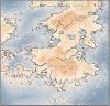
Also, I might as well add that you can adjust the water and ice levels of the map. What that means is that it's possible to simulate what our Altera would have looked like during an ice age.
Greetings Explorer, Navigate into the Lobby!
Register a free account today to become a member! Once signed in, you'll be able to participate on this site by adding your own topics and posts, as well as connect with other members through your own private inbox!
Be sure to "Get Whitelisted" to join the community on server!
And I always explain if asked. I never disagree without reason.oh he always does that
I love that you use the disagree vote.And I always explain if asked. I never disagree without reason.
Apparently disagree is the new dislike and you're not supposed to use it. No one told me, I guess.
I thought so. gonna modify that then.Centurius's capital is in the valley between two mountains, not on the side.
make meI thought so. gonna modify that then.
also, get involved scrub.

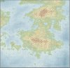
Interestingly enough, it appears that there's a ruin on the exact spot Diaedor's capital is...
the ruin was randomgenerated : PHuh- I actually had no idea when I placed that. Might have to try to figure that into my lore somehow.
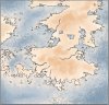
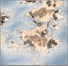
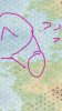
Its not pointing th right way for a grass tuft tho.I believe that little tuft of grass, as I refer to it, represents swampland.
Well this ruins my idea of making the rainfilled basin areas into marshes...There are a couple of other swamps, such as in southern Astenbech, but there aren't many.
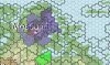
Thats the planIf you're doing Rondileau and Tarcheya both, you should include Arhemia and do that entire half of the continent in one map.